Today, for the first time in a while, I feel a literal spring in my step. Also a metaphorical one. For weeks now, I have felt strangely weighed down, either by my actual body feeling stiff and creaky, or my head feeling clouded into inertia. I’m not a fan of this feeling, which is why it feels good to write this post.

The literal spring comes from my legs feeling like they finally got some use as I hiked up, down, and around Mt. Wachusett in Central Massachusetts this past weekend. More on the details of that hike can be found below, if you just came here for the hiking details and have no need to hear my philosophizing about life.
A lot of folks out there talk about the power of a detox – and I sort of feel like that’s what yesterday’s 4-hour hike was for me. It was a chance to worry about nothing more than a few immediate, real-time things:
Sucking in enough oxygen to keep climbing up;
Placing my shaky feet to avoid breaking an ankle on the way down;
Watching (and occasionally helping) my dog navigate her way down some pretty steep rocks;
Oh, and of course, letting the gorgeous blue/green colors of summer in New England wash over my pale, office-bound, city dweller’s body.
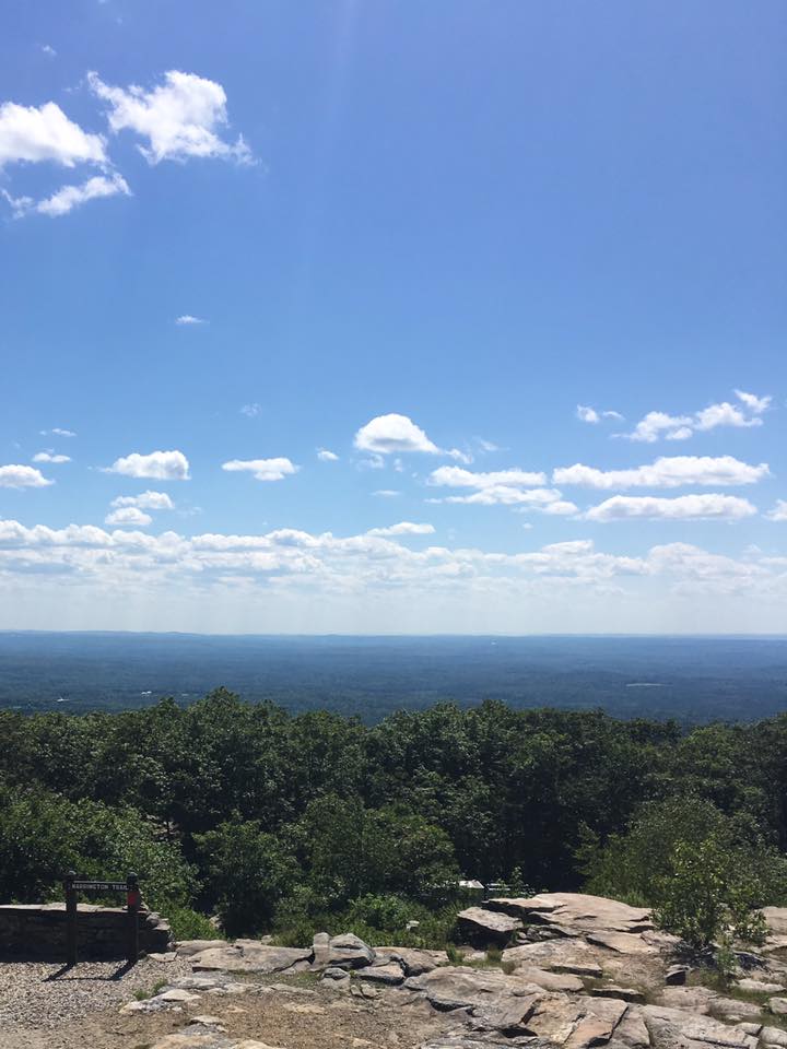
I didn’t take a lot of pictures, and failed at taking a panoramic photo (see the really long and skinny photo I posted here), proof that I probably shouldn’t even have taken out my phone as I enjoyed a nearly perfect summer New England Day.
We talk of hiking as therapy, and I guess, in my case, it’s true. I definitely felt like I’d hit the reset button on my soul this time around.
Now, for those who are interested, here are details of this hike.
Mt. Wachusett is the tallest mountain (just over 2000 feet) within a relatively short (just over an hour) drive from Boston. I have a hard time making the trip to NH (for Mt. Monadnock or the White Mountains) in a day, mostly because of how much my dog hates being in the car (plus I am SO BAD at getting up before the sun when I’m hiking solo), so finding something with a bit of elevation a little closer to home is always a bonus. I hiked this hill last year but took a relatively short route that left me feeling less than challenged. So this year I scoured the interwebs for other hikes and found a good one. Here’s an abbreviated description – I recommend getting a map of the Mt. Wachusett State Park so you can either follow this or find your own route. There was a whole box of them at the trailhead, or you can download it here.
From Boston, take Exit 25 (140 South) off of Route 2. Follow the signs to the Mt. Wachusett Ski Area. Avoid the first parking lot you see and turn right onto Bolton Road to the main Ski Area parking lot. Look for a light brown warehouse to the right of the main lodge. The trailhead is right next to it.
Your first leg is on Balance Rock Trail (yellow blazes). You will, after a relatively short and mild uphill hike, realize why it’s called Balance Rock trail.

There are lots of rocks and roots on this entire hike, FYI, so be prepared.
A little way beyond Balance Rock you’ll come to an intersection – take the Old Indian Trail. This trail will cross a few other trails, and also a few (4) ski slopes, and one summit road, but basically, just stay on this trail as it’ll take you to the summit. It’s about 1.2 miles long. There are a few places that are fairly steep, but nothing truly difficult, although if it’s rained recently, there will be mud and the rocks could be slippery, so it’s worth proceeding carefully. This was my first real uphill in quite a while, so I stopped several times to…ahem…catch my breath, but the good news about this hike is that it’s never the same challenge for very long. If it gets steep, it’ll flatten out pretty soon. Unlike a hike into the Whites, for example, you’re not facing 3 miles of steady uphill until you get to the good stuff.
Right before you hit the summit you’ll come upon a ski lift platform with a lovely view of a lake – if one of the gondolas is open for lounging, take it, and remember that these summer days are what make the long, snowy winter bearable.

Anyway, the good stuff on this hike is 360-degree summit views that on a clear day, will show you the Boston skyline, the Berkshires, and Mt. Monadnock. The summit is likely to be crowded unless you’re hiking really early, but the views are worth it. Definitely make sure you climb up to the viewing platform and snap some pictures of the prettiness. There are plenty of warm rocks to grab a snack and a drink on as you soak in the views.

There are several options to get down from the summit. You could turn around and go back the way you came, but I’m a loop person, so I chose a different way down.
Harrington Trail, my way down, gets pretty steep and rocky. It reminded me a lot of coming down East Oceola in the White Mountains. There were a few times when my pooch watched me slide down a big rock on my butt and gave me a look as if to say “I’m not jumping that.” Dogs should be on leash in the park, but on the hike down, I did let Sadie off occasionally because it was simply safer for her and me to let her find her own way.
This trail heading down was significantly less crowded than the Indian Trail heading up, but it was also later in the day so that probably contributed to the relative peace and quiet. Anyway, Harrington Trail will cross two “roads” as it descends, and you want to take the 2nd one and head right. This is West Road, and it’s flat and goes on for a while. I was getting pretty zen at this point, so I don’t know the mileage, but I’d say it’s at least a mile or a mile and half before you reach the gate marking the end of the road.
There, you’ll turn right onto West Princeton Road, which is open to traffic, so be careful. You’ll stroll along here for a bit, and then you’ll want to take a right onto North Road, also marked by a gate. This road climbs a bit, but it’s gentle.
There will be an intersection relatively soon, and you want to take a left onto it. This is Balance Rock Road, and soon you will find yourself back at the intersection of Balance Rock Trail. Take a left onto the trail and head back past Balance Rock to the parking lot.
I read that this hike should take 5-6 hours and is rated moderate/difficult. I would say that, unless you are with kids, stopping frequently, and/or having a several course meal on the summit, it’s more like 4+ hours. The total mileage was about 6.25 miles. There are only two parts I would call “difficult”: one stretch of Indian Trail near the summit, and coming down Harrington Trail. Otherwise, this is a pretty easy/moderate hike, with the benefit of a lot of different terrains so you never get bored, and plenty of flat strolling that allows you to just zone out and enjoy being in the woods.
So if you can’t make it up to the White Mountains, this is a nice alternative. It’s not a 4,000 footer, but it’ll get your heart pumping and give your legs a little challenge.
If you do this hike, let me know what you think in the comments! Have a great day, everyone.
